Improving our Understanding of the Environment by Analyzing Geospatial Data

In the past few decades, the use of GIS technology has slowly started to change the way we think about spatial data. With the current software applications it’s very easy to visualize, manipulate, and analyze the vast amounts of data that businesses and governmental agencies collect. We can easily discover relationships and patterns about different data sets that wouldn’t have been possible in the past. GIS technology has taken the typical database residing in a mainframe computer and turned it into something that is more useful today than it ever was before. This is precisely what GIS technology is. It is a tool that can be used to improve our understanding of the world and how its various earth systems interact with the increasingly anthropogenic world using data that already exists.
Understanding Impacts to Endangered Species
Biologists around the country have spent years studying migratory patterns and habitats of many animals. With this large amount of data, GIS analysts can plot the migration paths and critical habitats on maps for everyone to see. Overlaying these maps with land ownership maps, transportation corridors, and floodplains allows users to determine areas and species that could be impacted in the future. Government agencies can use this data to help plan for future developments that will minimize their impact to endangered species. Ultimately, when this data is stored and visualized in a GIS environment our leaders can make the most informed decisions that they possibly can with regards to impacts on endangered species. This will lead to a better world for all of Earth's inhabitants.
Modeling the Potential Impacts of An Oil Spill
When planning for a environmental disaster, such as an oil spill, GIS tools can help make predictions about the extents and severity of these disasters. GIS based oil spill models that simulate tidal patterns and ocean currents can help identify parts of the coast that are at a higher risk for a catastrophe. Analysts, government leaders, and oil prospectors can all use this information to help make more environmentally friendly decisions when it comes to locating, transporting, and finding crude oil.
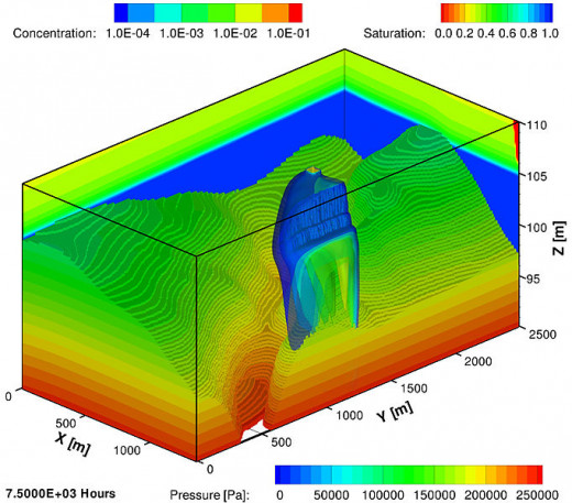
Mapping Groundwater Supply and Potential Contamination
Did you know that approximately 15% of American's use a private well to obtain their drinking water? What's more is that many municipal water suppliers are also utilize wells to turn groundwater into dinking water. In fact, groundwater resources have become an integral part of America's water infrastructure. So much so that the impacts of even a small amount of contamination can have a catastrophic effect on the general population.
This is where GIS tools and geospatial data can come in handy to help manage our groundwater supplies. By mapping the locations and depths of water wells and overlaying it with the locations of industrial sites, abandoned mines, and locations where polluted stormwater can enter the aquifer, analysts can calculate and predict the relative contamination risk facing our groundwater resources. Additionally, population data can be combined with the geospatial well information to analyze and compare the demand for water versus the available supply.
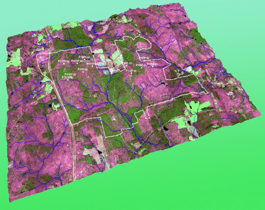
Monitoring the World's Rainforests
One of the biggest environmental problems facing the world today is rapid deforestation. In fact, I once read that the world's forests are disappearing at a rate of more than 1 acre every second. With this alarming rate of deforestation, it's easy to see the kind of problems that it can cause. With GIS, the forests can be monitored through a combination of measurements made on aerial photography, LIDAR digital terrain models, and continually updated urbanization data. Country's with large forests at risk can utilize a GIS based deforestation analysis to help better manage this finite resource. For instance, government leaders can use this data to set policies for replanting efforts, zoning, and even future urban planning. Without GIS, these kinds of problems would be a significant challenge overcome as definitive solutions would be harder to come by.
Final Thoughts
We have only just scratched the surface of the potential ways that geospatial data can be used to improve our understanding of the environment. With the use of high powered computers, vast databases of information, and an intuitive set of GIS software applications, humanity is learning how to move towards being closer to nature again.